• BTS in Gwanghwamun – Location Guide & Transportation Information

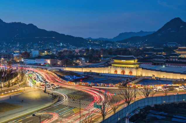
    If you’re visiting Seoul and searching for BTS-related spots, Gwanghwamun Square is one of the most iconic locations in the city.

    This central area has hosted multiple K-POP related events, pop-up exhibitions, and fan gatherings — and it remains a must-visit location for ARMY visiting Korea.

    📍 Where is Gwanghwamun Square?

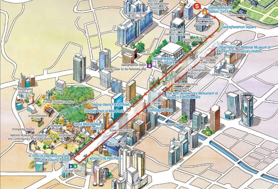
    Gwanghwamun Square is located in central Seoul, directly in front of Gyeongbokgung Palace.

    It is surrounded by major cultural and historical landmarks including:

    • Gyeongbokgung Palace
    • Sejong Center for the Performing Arts
    • National Museum of Korean Contemporary History

    This makes it a perfect stop for fans combining tourism + BTS pilgrimage.

    🚇 Transportation Guide

    The easiest way to reach Gwanghwamun Square is via subway.

    ✅ Subway Access

    Line 5 – Gwanghwamun Station

    • Exit 9 (most direct access to the square)
    • Exit 7 (alternative access)

    Other nearby stations:

    • Line 3 – Gyeongbokgung Station (Exit 5)
    • Anguk Station (within walking distance)

    Because the square stretches long vertically, different exits bring you closer to different areas.

    🎤 Why BTS Fans Visit Here

    Gwanghwamun is not a permanent BTS museum — but it has hosted:

    • BTS anniversary events
    • Pop-up exhibitions
    • Fan-led birthday events
    • Special LED media displays
    • Cultural campaign collaborations

    Because of its central location and symbolic status in Seoul, it is often selected for large-scale public K-POP events.

    📸 Best Time to Visit

    • Evening (7PM–10PM) for city lights
    • Spring & Autumn for comfortable weather
    • Weekdays for fewer crowds

    🏨 Where to Stay Nearby (Travel Intent Tip)

    If you’re planning to visit:

    • Myeongdong area (10 min away)
    • Jongno district
    • City Hall area

    🔥 Final Thoughts

    If you’re an ARMY visiting Seoul, Gwanghwamun Square should be on your list.

    Even when there is no official BTS event happening, the area’s atmosphere, accessibility, and historical backdrop make it one of the most symbolic K-POP-friendly spaces in Korea.

  • How to Get from Incheon Airport (ICN) to Yangcheon Cultural Center Grand Theater

    If you’re attending a concert or fan meeting at Yangcheon Cultural Center Grand Theater, here’s a complete transportation guide from Incheon International Airport (ICN) to the venue.

    Yangcheon Cultural Center is located in Yangcheon-gu, Seoul, near Omokgyo Station (Line 5).

    📍 Venue Address

    Yangcheon Cultural Center
    367 Mokdongseo-ro, Yangcheon-gu, Seoul, South Korea

    🚆 Option 1: Airport Railroad + Subway (Recommended)

    Estimated Time: 70–90 minutes
    Estimated Cost: 4,500–5,500 KRW

    Step 1

    Take the AREX (Airport Railroad) from:

    • Incheon Airport Terminal 1 or 2
      → Get off at Hongik University Station

    Step 2

    Transfer to Subway Line 2 (Green Line)
    → Get off at Sindorim Station

    Step 3

    Transfer to Subway Line 5 (Purple Line)
    → Get off at Omokgyo Station

    Step 4

    Walk about 10–15 minutes to the venue

    This is the most budget-friendly and reliable option.

    🚌 Option 2: Airport Limousine Bus

    Estimated Time: 80–100 minutes (depending on traffic)
    Cost: Around 17,000 KRW

    Take an airport limousine bus heading toward Mokdong / Yangcheon area.

    ⚠ Traffic congestion is possible on weekends and event days.

    🚖 Option 3: Taxi

    Estimated Time: 60–75 minutes
    Estimated Cost: 60,000–80,000 KRW (depending on traffic & tolls)

    Recommended if:

    • Traveling in a group
    • Carrying heavy luggage
    • Arriving late at night

    🚇 Nearest Subway Station

    • Omokgyo Station (Line 5)

    Exit and follow directions toward Yangcheon Cultural Center.

    Public transportation is strongly recommended on event days.

    🎵 Travel Tips for Concert Day

    • Allow extra time (at least 20–30 minutes buffer)
    • Avoid peak rush hours (7–9 AM, 6–8 PM)
    • Use a T-money card for convenience
    • Check Naver Map or Kakao Map for real-time directions